Pages

Friday, August 28, 2015

Red Mountain Hike and Ride 8/28/2015

I'd been doing quite a bit of hiking and decided it was time to warm up the ATV and combine a little hike and ride.  So, I headed up on Corkscrew Pass.  There's a road to the south at the top of the pass that goes down to a small parking area.  From there you can hike up a couple of the Red Mountains. It's still hazy due to the wildfires up in the northwest, so the photos are not the greatest.


View from the pass looking east.


View from the beginning of the hike.  There are mine remains all over this area.  There are only faint trails in the area.  It's sometimes difficult picking a route as some are easier than others.


Somewhat hazy horizon looking to the north toward Ouray and Montrose.


I was really surprised to still find some Columbines up here.


Headed up to the first summit.  This is looking back down on the Corkscrew Pass road.  There's a vehicle on one of the switchbacks.


Stunning views from the first summit.  Ironton Park and Crystal Lake are vaguely visible in the center of the picture.


After dropping to the "spine" between the mountains I could see a Jeep tour vehicle on the top of the Red Mountain where I was headed.  What fun is that?


Walking across the narrow ridge between the two mountains.  It's very narrow in spots and loose enough that a lot of caution is needed.  It's a long slide to the bottom.


Another shot on the ridge.  The Gopro wide angle exaggerates it a bit.  But, it's still narrow and steep on both sides.


Nice views across the valley.  Mount Sneffels is front and center in the background.  This San Juan landscape always amazes me in how rugged it is.  It's both a chore and a pleasure to hike these mountains.  It cleanses the lungs and the soul.


Lots of iron in these hills.  Plenty of sulphur too.  There were vent holes that I went by that were very strong with the smell of rotten eggs.  Upper right is Corkscrew Pass.  My ATV is just off the upper right out of the picture.  The lower summit I first climbed is blocking the view of most of the Corkscrew road.  To get back to my ATV it's back down the ridges between the mountains.


Sorry, I couldn't help another Colorado columbine shot with multiple layers of San Juan landscape.


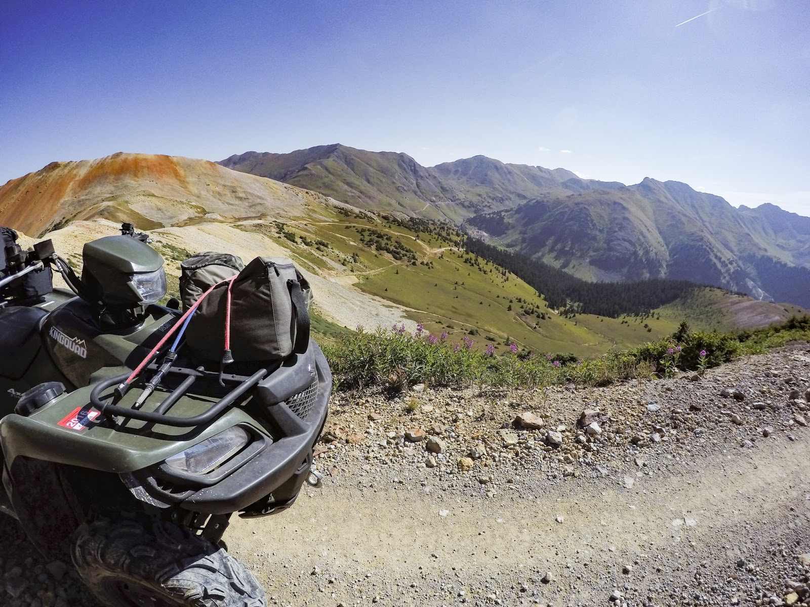
After returning to my ATV, I decided to take a ride on down the other side of the pass to get out of the wind.  It was howling all day.  On the way down I could see the site of the Gold King Mine EPA cleanup disaster that inundated the Animas River with mine chemicals.  There's still a lot of activity down there and will be for some time to come.  The flow area is plainly visible.


Headed back down the pass to my pickup.  I never can get enough of being out in this country.


Parting shot on the way down.  Another great day in God's creation!

Friday, August 21, 2015

Blue Lakes Hike - New View 8/21/2015

I try to get up to the Blue Lakes at least once each year - hopefully more.  Unfortunately, on this trip the smoke haze from the fires in the northwest US and northern Idaho had filtered into the area for about a week.  This summer it has been either rain or fire smoke to thwart hiking and photography.  But, regardless of the conditions (unless they're just unbearable) I decided to head on up to the Blue Lakes anyway.  However, I usually follow the trail and go on up to the upper lakes.  After checking things out on Google Earth, I decided I'd like to bushwhack up the west slopes above the lower lake and see what the perspective was like up there.  So, that's what I did.  Since I knew it would not be a place to haul nice photography gear, I decided this would be mostly a Gopro photo session.  I had my point and shoot camera, but didn't use it much.  The Gopro gives an interesting view with its wide angle lens.  I actually like several of the shots that I took with it.


I arrived at just about sunrise and headed up the trail.  I was surprised that the sky looked somewhat blue.  It had been gray and white for a week.


It actually looks like this trip won't be a photography bust after all.


Even though it was later in August, there were still a few wildflowers around.


The sky is still not too hazy as I approach the lower lake.  The goal is the ridge just above the tree tops on the right.


The lower lake was beautiful as usual.  I still say this is one of the most beautiful places on planet earth.


View looking back to Mt. Sneffels on the way up the mountain.


My rock perch high above the lower lake.  Oops - got my knee in the picture.  It's getting more hazy now, but still fantastic views.


A few columbines were still nestled in the rocks up high.  That's a harsh environment to grow in?


There were signs of mountain sheep all over this area.  On the way down I noticed this bed where the grass was packed down right in front of the rock in the center of the picture.  A nap-spot with a view to die for!


I returned to the lake down this steep grassy slope.  There were little "ball-bearing" rocks hidden under the grass.  Three times my feet zipped out from under me and I would instantly be on my back, sliding down the slope.  A few scratches were the only damage - but, it got old really quick.


Couldn't resist a photo of this old snag as I got back down near the lake.


I also had to get a parting shot of the lower lake.


On the way down I ran into these nice folks from Texas.  They also have a home in Ridgway.  As I approached he said, "I bet you didn't expect to see horses up here today".  Me laughing - "that's for sure, or any day for that matter."  Him - "the locals said people ride horses up this trail all the time."  Me - "I've never seen horses on this trail, nor sign of them. Not sure those locals know what they're talking about."  She - "there were some really steep parts that were scary".  Me - "well you're past the steepest parts, so you can enjoy the trip from here on."  She "oh good."


Now there's evidence of horse travel on this trail.


On the way down I noticed a narrow spot where the bank had nearly given way with one of the horses.  It doesn't look it, but this is a very steep hillside down to the left.  Note the sunken hoof prints on the left edge of the trail.


Lots of "shrooms" due to the summer rains.


I interrupted this doe taking an afternoon siesta!


The Gopro makes for interesting overhead shots.  Just as I got back to my pickup, it began to rain and hail.  My timing was perfect.  Another fantastic hike to the Blue Lakes was in the books.  I can't wait to come back again.  Thank you Lord for such beautiful places and the strength to visit them.  I'm blessed!

Friday, August 7, 2015

Crag Crest Rainfest Hike 8/7/2015

Crag Crest Trail on Grand Mesa is a fantastic, easy trail that gives stunning views of the lakes below. Many folks just hike up to the top and then back.  But, the trail makes a 10 mile loop.  Half is on the crest and the other half through the forest below.  I always like to make the loop whenever possible.  I knew the forecast was "iffy" on this day, but in this rainy summer, if you don't hike in the rain, you won't go hiking.  So, away I went.  My photography this day was fairly dismal due to the weather. But, all days are not perfect - I have to show the good and the bad.


The first lake passed from the east trailhead is Upper Eggleston.  I've spent many a day fishing this lake back when my dad was still alive.  We used to be able to drive up to this lake on a rocky, twisty road that was much quicker to travel afoot.  We also camped at this lake several times and so there are great memories.


On the way between Upper Eggleston and Butts Lake (yes, that's its proper name) I met this doe who walked on the trail in front of me for a bit.


As I got near Butts Lake, the sun was still shining and I was hoping it wouldn't be rainy like Mr. Baahumbug Weatherman predicted.  At least for now it looks good.  This area used to be in the trees. A micro-burst came through a few years ago and mowed down acres of trees.


Just above Butts Lake I could still see under the coming rain clouds clear to the San Juan Mountains south of home.  I had come up here to avoid the heavy rain that was predicted for the San Juans.  At least for now, the San Juans were in sunshine and I was wondering if I'd made the right decision.  The lake below is actually just a pond that often dries completely during the dry summers.  Not this year!


A few columbines were still in bloom - my favorite mountain flower.


As I reached the crest the sky opened up and it rained the entire rest of the 10 mile loop.  But, the flowers were amazing.  They and the grasses were so tall that slogging through them in the rain left me saturated from the waist down.  Glad I wore shorts instead of long pants.  My legs are waterproof! But, water would squish out of the tops of my shoes on every step.  Fun!


Even though it was raining, beauty was still everywhere. Surprisingly, I met a couple lady hikers who had the same "hike in the rain or stay home" attitude as me.  But, they didn't even have rain coats on. Their hair was sticking to their heads and faces, but they were laughing and having a great time anyway.  I met them twice, so knew they made the entire loop too.  They were locals and had also been on the trail multiple times.


The flowers and grasses were unbelievable.  Most of the grass was more than waist tall.  Is that blue sky up there? - come on over here where I am.  It didn't listen.


This is the view out over Big Eggleston Lake.  I'm almost back to my pickup by this time.  The amazing thing about all the poor weather this day, was that there was very little lightning.  Rain doesn't bother me, but I'll pass on the lightning.  So, another great day hiking was in the books - thank you again Lord!